

3D Architectural Mapping for Columns, Arches and Ornate Detail
3D Architectural Mapping for Columns, Arches and Ornate Detail
Columns, arches and carved cornices are what make a building worth a second look. They are also what make it hard to project on, because every edge, recess and curve has to line up with the light.
We map shows to detailed architecture for brands, venues, universities and congregations, on the outside of a building or on the decorated walls inside it. If your building has detail you want the show to follow, send us photos of your building.
How 3D architectural mapping follows every column and arch
3D architectural mapping fits the content to the true shape of the building, so light runs up a column, fills an arch or picks out a cornice instead of washing flat across the front. Content is mapped to align with architectural features like windows, columns and ledges.
What makes that possible is a measured 3D scan. A scan shows every cornice and pilaster as it really is, so masks fit, edges meet, and illusions land where the eye expects them to.
The same geometry opens the door to depth effects. With true geometry, content can create illusions that appear to reshape the surface. Those effects have their own page on 3D projection mapping.
What we handle on a detailed building
- Capture. We choose the method for the site: tripod laser scanners for millimeter-level accuracy, handheld LiDAR for fast interiors, and photogrammetry or drone passes for tall facades and roofs.
- Extra angles for deep detail. Deep recesses and undercuts need extra angles because a single pass rarely sees everything, so we plan coverage until every nook is visible in multiple frames.
- A model artists can paint on. The point cloud becomes a mesh with UVs, so content can be painted directly onto the geometry. Key features like cornice lines get a higher scan density.
- Content drawn to the stone. Artists build the animation on the same mesh, so final frames already match the real surface. Our animation and visual storytelling team leads that work.
- Previsualization. We test projector locations, lenses and blends on the model, and place overlap zones where they are least visible.
- On-site alignment. We position the hardware, run auto-alignment where appropriate, and finish with manual mesh tweaks.
Columns, arches, cornices and ornate interiors
Columns and pilasters. A colonnade is a row of separate surfaces. Each column can carry its own color or motion, and the dark gaps between them become part of the rhythm of the show.
Arches and windows. Openings frame the content. A show can fill an arch, trace its outline in light, or leave the glass dark so the stone around it carries the image.
Cornices, relief and carving. Fine detail rewards a dense scan and tight masks, so a carved band or a row of brackets can light up one piece at a time.
Ornate interiors. Architectural mapping covers interior walls as well as building facades. Inside, the audience stands much closer, and when people will be near a wall, the image needs higher pixel density and careful lens choices to stay crisp.
For whole-building shows on towers, hotels and venues, see building projection mapping. Heritage sites have their own page on historic building projection mapping, and design pitches on scale models are covered by architectural projection visualization.
Detailed buildings we have mapped
- Chabad of Summerlin, Las Vegas. For an outdoor Chanukah celebration, our technicians set up two 4K projectors at opposite sides of the synagogue and edge-blended them to reduce shadow on the building. We then programmed the shape of the building in MadMapper so the visuals followed every curve and corner.
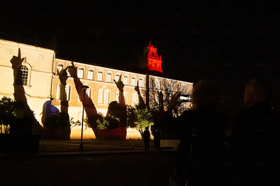
- Texas Tech centennial. For the university's 100th anniversary in February 2023, our team carefully captured each corner and feature of the historic Administration Building. Seven 4K Barco projectors mounted on custom truss structures ran the 5-minute show.
- Tropicana world record, Las Vegas. We used specialized software and photogrammetry to represent the architecture accurately, and our custom FORGE ANVIL server adapted the content feed to the forced perspective of the building. The live video game display was recorded as 47,397 square feet.
3D architectural mapping FAQ
Not always. For perfectly flat rectangles, a full scan may be unnecessary, and simple field measurements and a quick survey can be enough. Once content must wrap edges, follow relief or span curved surfaces, scanning moves from nice to have to necessary.
Yes. Once captured, the model becomes a reusable asset for seasonal shows or touring versions.
Mirrors, glass and polished metals confuse many scanners. We plan additional angles, use cross-polarized photography for photogrammetry, or mask those regions for manual treatment in content.
Didn’t find what you were looking for?
Our team is happy to walk you through your project and answer anything else
Map your building's detail
Send us photos or drawings of the building, your dates, where the audience will stand and what the show is for. We will reply with a plan covering capture, content and projector placement. To see everything we do, visit our projection mapping services page, or book a call with our team.